


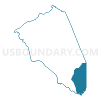
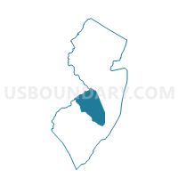
Bass River township voting district 1, Burlington County, New Jersey
About
Outline

Summary
| Unique Area Identifier | 617248 |
| Name | Bass River township voting district 1 |
| County | Burlington County |
| State | New Jersey |
| Area (square miles) | 78.27 |
| Land Area (square miles) | 75.04 |
| Water Area (square miles) | 3.22 |
| % of Land Area | 95.88 |
| % of Water Area | 4.12 |
| Latitude of the Internal Point | 39.65844300 |
| Longtitude of the Internal Point | -74.44812690 |
Maps

Graphs
Select a template below for downloading or customizing gragh for Bass River township voting district 1, Burlington County, New Jersey


Neighbors
Neighoring Voting District (by Name) Neighboring Voting District on the Map
- Barnegat township voting district 5, Ocean County, NJ
- Galloway township voting district 8, Atlantic County, NJ
- Little Egg Harbor township voting district 11, Ocean County, NJ
- Little Egg Harbor township voting district 2, Ocean County, NJ
- Little Egg Harbor township voting district 7, Ocean County, NJ
- Little Egg Harbor township voting district 8, Ocean County, NJ
- Port Republic city ward 2 voting district 1, Atlantic County, NJ
- Washington township voting district 1, Burlington County, NJ
- Woodland township voting district 1, Burlington County, NJ
Top 10 Neighboring County Subdivision (by Population) Neighboring County Subdivision on the Map
- Galloway township, Atlantic County, NJ (37,349)
- Barnegat township, Ocean County, NJ (20,936)
- Little Egg Harbor township, Ocean County, NJ (20,065)
- Woodland township, Burlington County, NJ (1,788)
- Bass River township, Burlington County, NJ (1,443)
- Port Republic city, Atlantic County, NJ (1,115)
- Washington township, Burlington County, NJ (687)
Top 10 Neighboring Place (by Population) Neighboring Place on the Map
Top 10 Neighboring Elementary School District (by Population) Neighboring Elementary School District on the Map
- Galloway Township School District, NJ (37,349)
- Barnegat Township School District, NJ (20,936)
- Little Egg Harbor Township School District, NJ (20,065)
- Woodland Township School District, NJ (1,788)
- Bass River Township School District, NJ (1,443)
- Port Republic City School District, NJ (1,115)
- Washington Township School District, NJ (687)
Top 10 Neighboring Secondary School District (by Population) Neighboring Secondary School District on the Map
- Lenape Regional School District, NJ (140,272)
- Greater Egg Harbor Regional School District, NJ (74,242)
- Pinelands Regional School District, NJ (26,458)
Top 10 Neighboring State Legislative District Lower Chamber (by Population) Neighboring State Legislative District Lower Chamber on the Map
- General Assembly District 9, NJ (236,923)
- General Assembly District 2, NJ (234,905)
- General Assembly District 8, NJ (227,817)
Top 10 Neighboring State Legislative District Upper Chamber (by Population) Neighboring State Legislative District Upper Chamber on the Map
- State Senate District 9, NJ (236,923)
- State Senate District 2, NJ (234,905)
- State Senate District 8, NJ (227,817)
Top 10 Neighboring 111th Congressional District (by Population) Neighboring 111th Congressional District on the Map
Top 10 Neighboring Census Tract (by Population) Neighboring Census Tract on the Map
- Census Tract 105.01, Atlantic County, NJ (7,299)
- Census Tract 7340.01, Ocean County, NJ (7,185)
- Census Tract 7361.01, Ocean County, NJ (5,696)
- Census Tract 7047, Burlington County, NJ (3,918)
- Census Tract 7360.01, Ocean County, NJ (2,861)
Top 10 Neighboring 5-Digit ZIP Code Tabulation Area (by Population) Neighboring 5-Digit ZIP Code Tabulation Area on the Map
- 08205, NJ (28,626)
- 08087, NJ (24,104)
- 08005, NJ (22,448)
- 08215, NJ (13,442)
- 08241, NJ (1,103)
- 08019, NJ (925)
- 08224, NJ (573)